|
Table of Contents
Presentations
- 12-13-2012 Pentwater, US Army Corps of Engineers
|
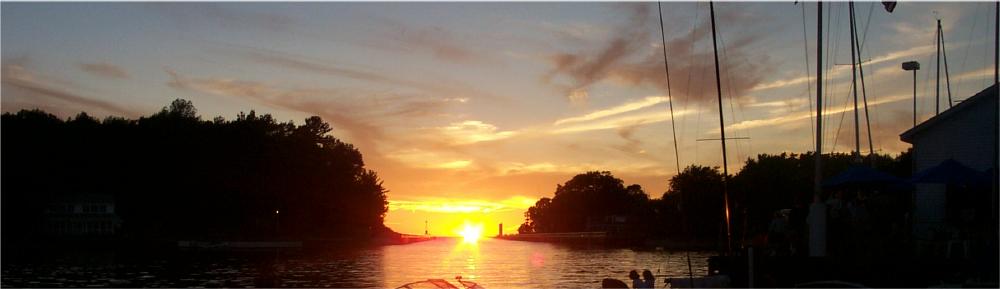
Boat traffic between Lake Michigan and Pentwater Lake is extremely important to the economic health of our community. It supports the fishing community, and brings boats, guests, shoppers, and potential residents to the Pentwater area. Inability to use the channel would adversely affect life in the Pentwater area, and would almost certainly decrease property values and tax revenues.
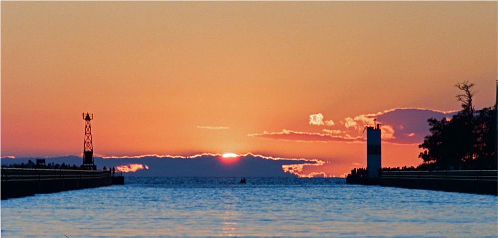
The channel that provides the connection fills with sand, and has required dredging almost every year for at least 30 years. Historically, it has been as shallow as 2 feet in 1867 and 1921. In the past, the dredging has been funded by the federal government. It seems very unlikely that such funding will be available this year, and very uncertain about future years.
The shoaling problem is compounded by the decreasing level of Lake Michigan and, of course, Pentwater Lake. The latter problem will be detailed below.
To address this issue, a group of private Pentwater area citizens worked in 2012 to determine the extent of the problem, and to generate the approximately $50,000 that was required to dredge that year. The problem of shoaling in the channel, and the need for dredging, is likely to persist for the foreseeable future.
Contributions can be made through The Community Foundation for Oceana County. This can be done online
|
Here
Select "Protect Pentwater Harbor Campaign Fund"
|
Checks shoud be made out to "Community Foundation for Oceana County" with a memo of "Protect Pentwater Harbor Fund"
These can be mailed to
|
Protect Pentwater Harbor Fund
The Community Foundation for Oceana County
PO Box 902
Pentwater, MI 4944
|
The Community Foundation for Oceana County is a Section 501(c)(3) Organization. Contributions should qualify as deductions for Federal taxes.
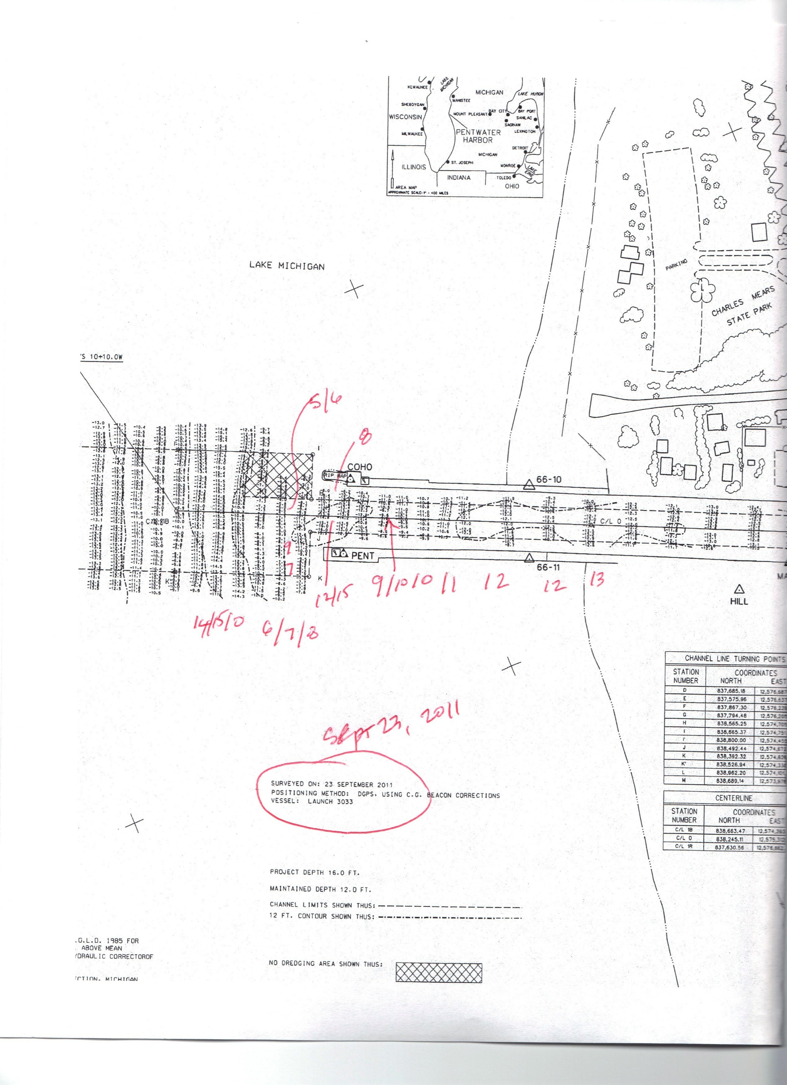
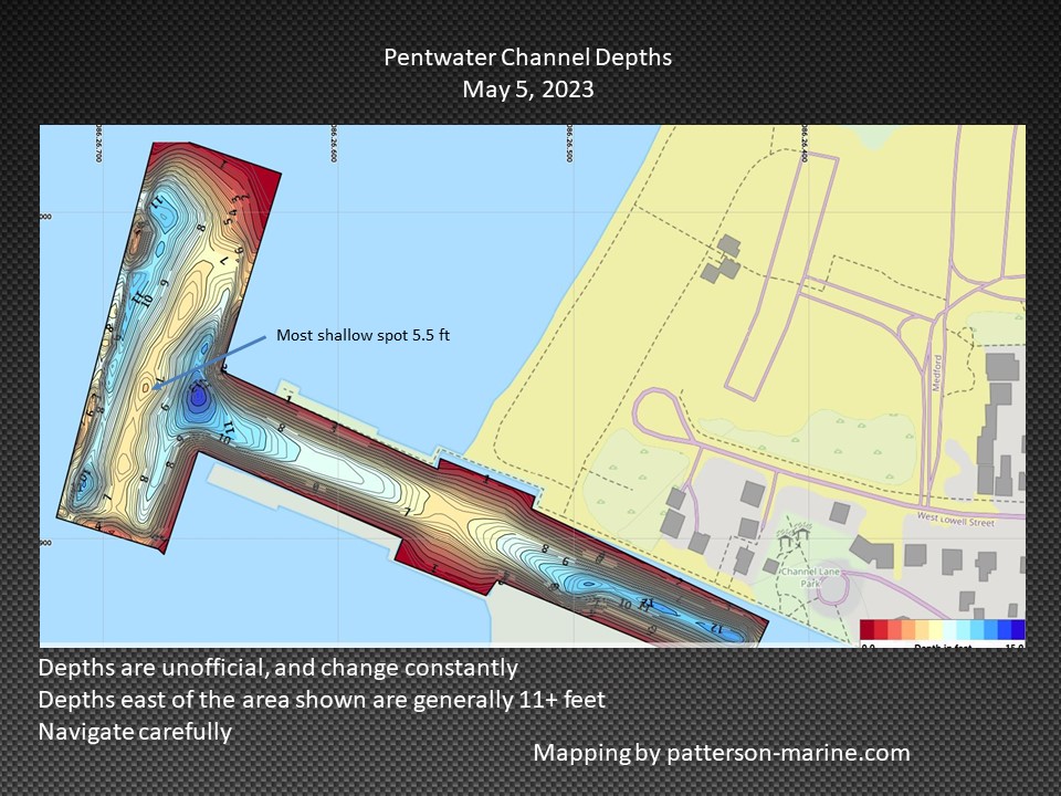
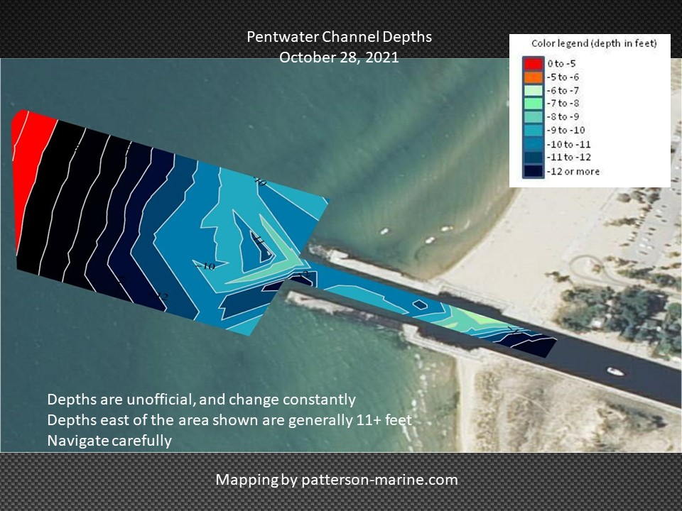
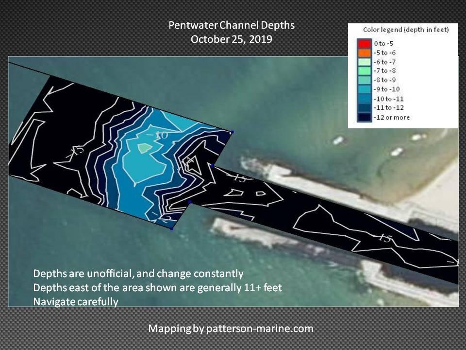
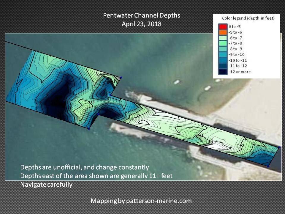
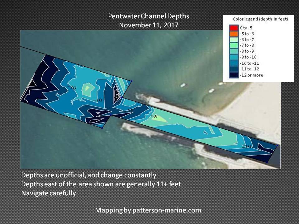
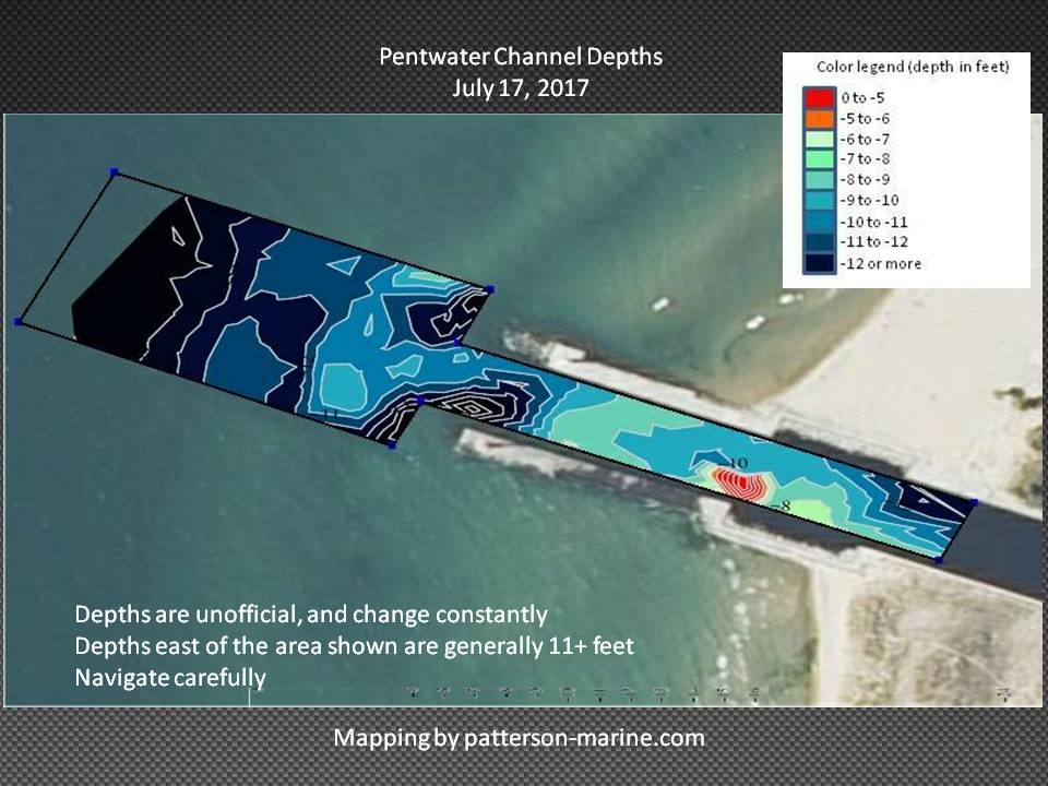
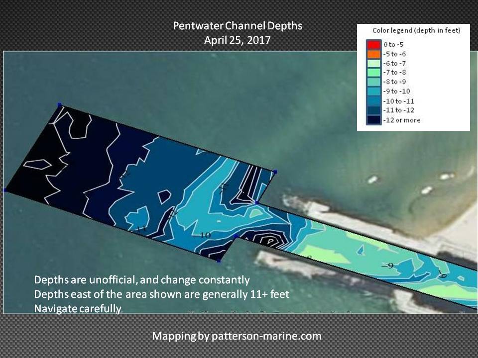
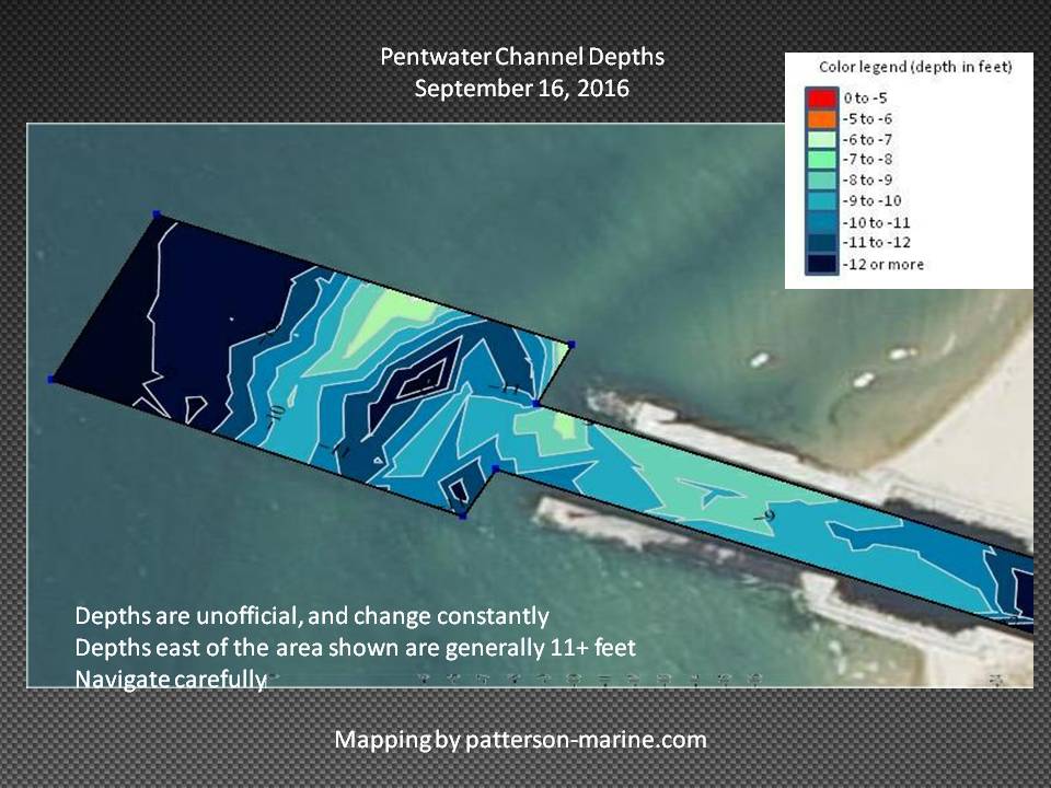
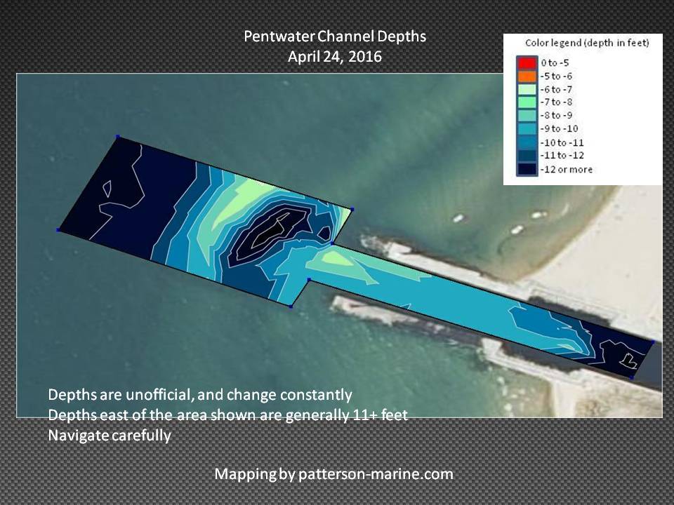
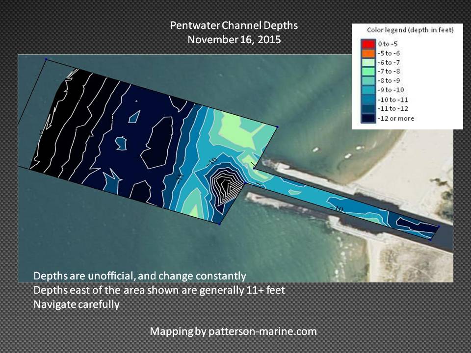
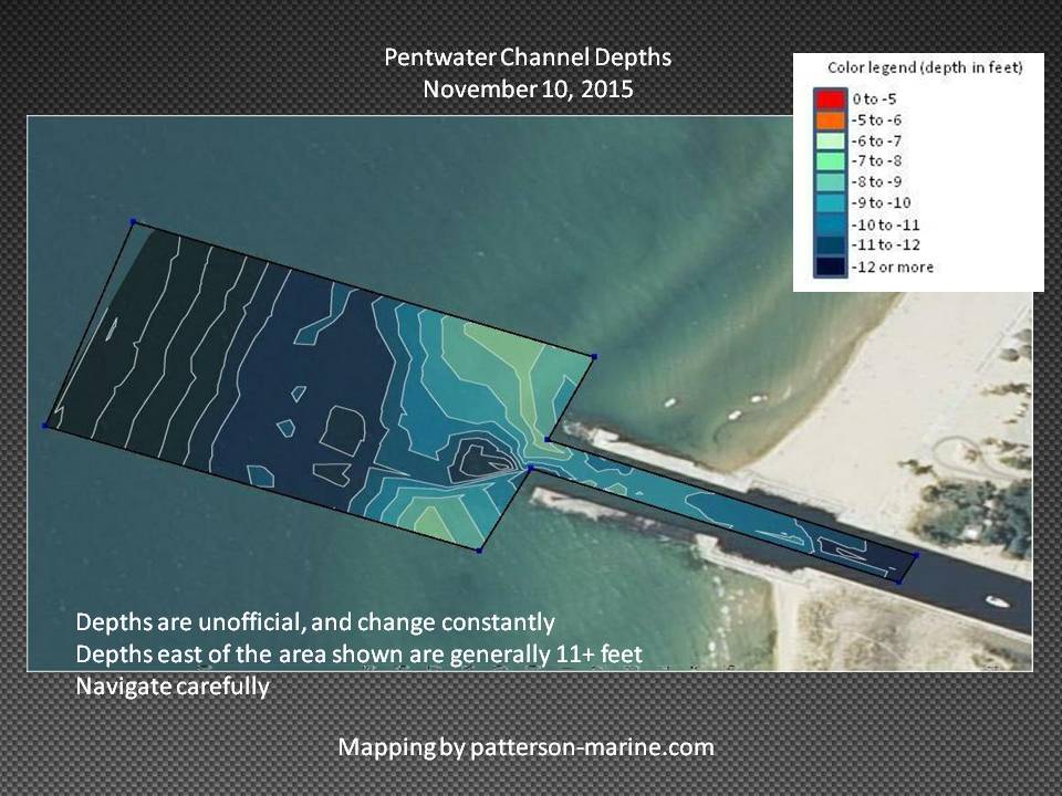
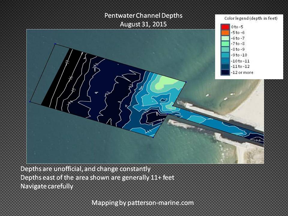
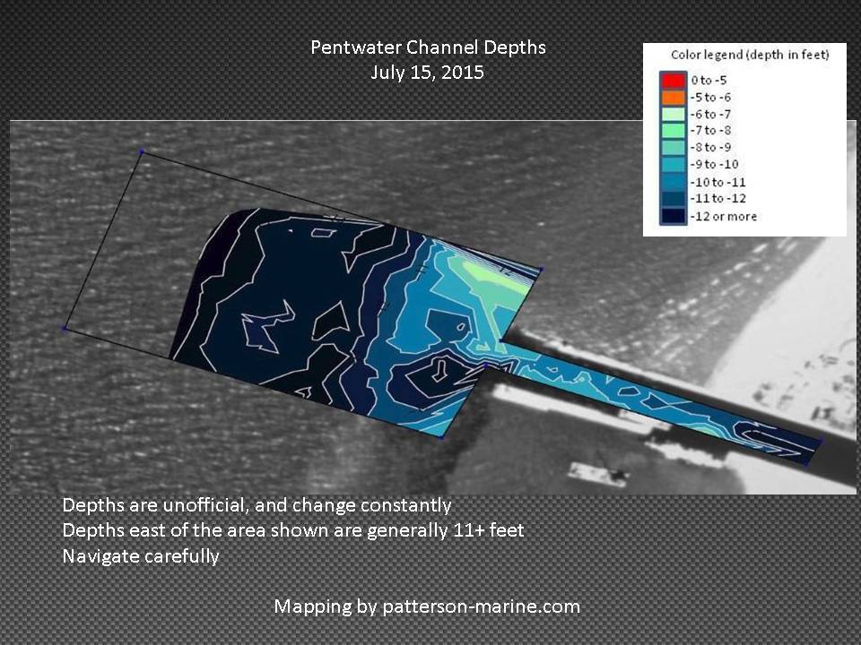
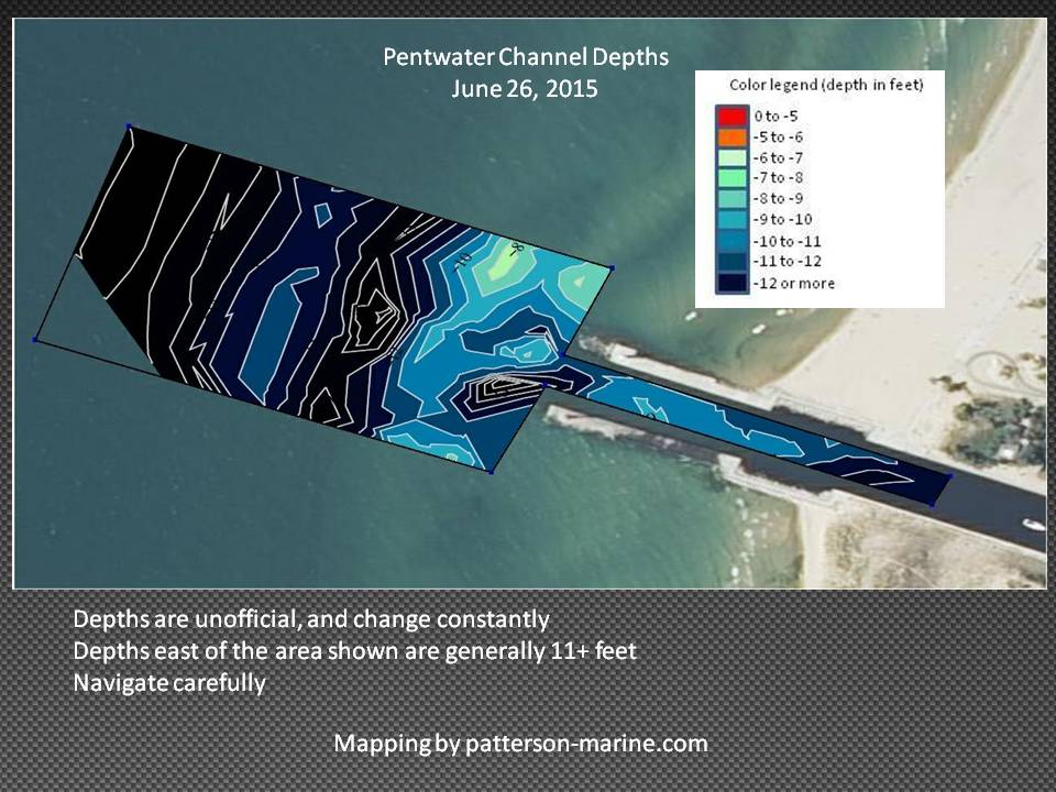
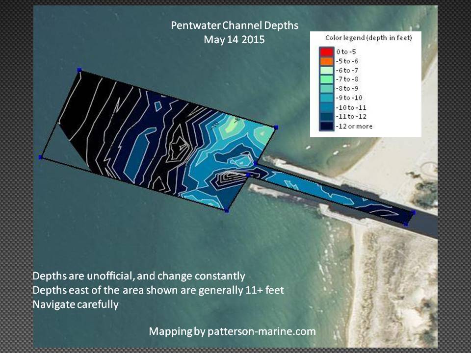
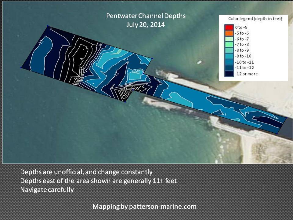
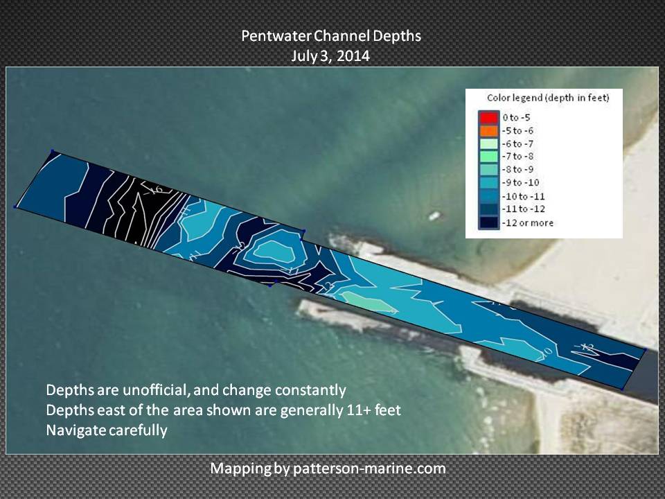
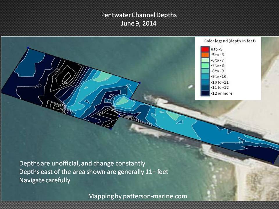
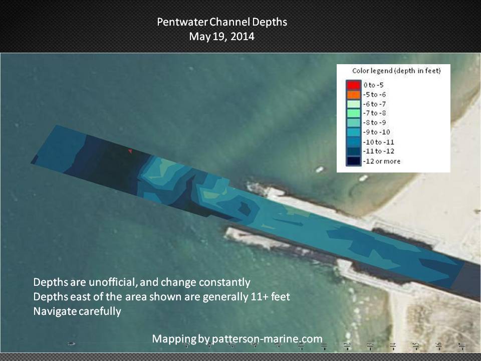
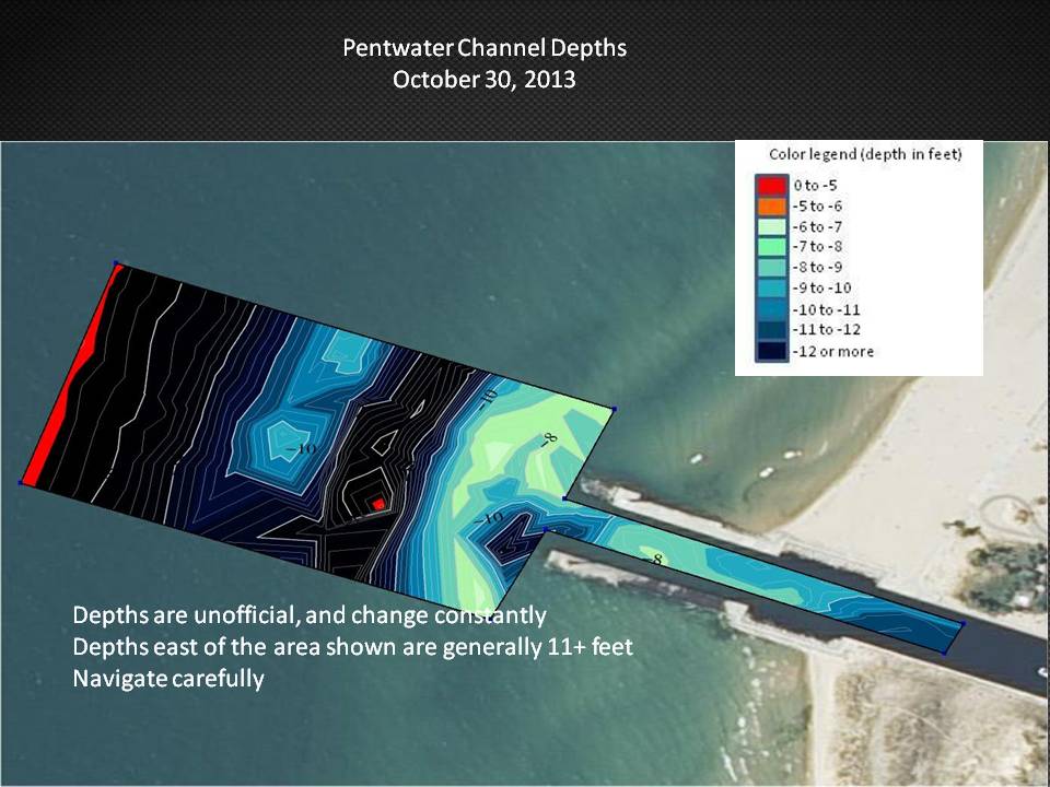
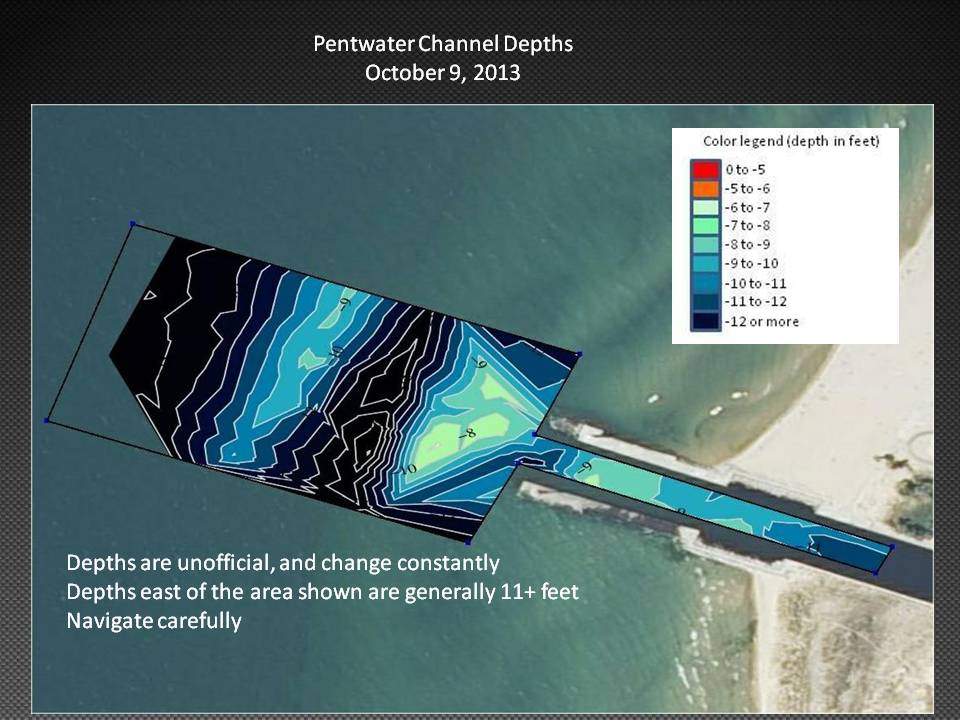
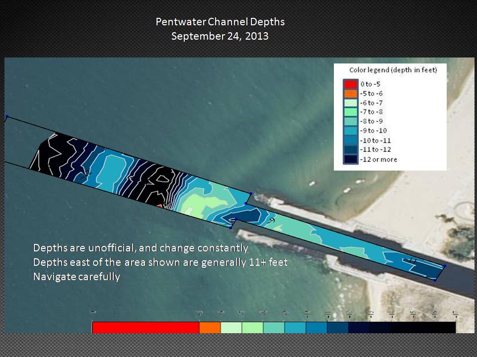
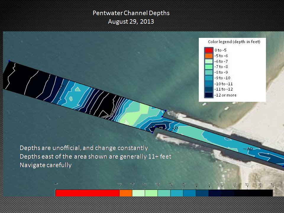
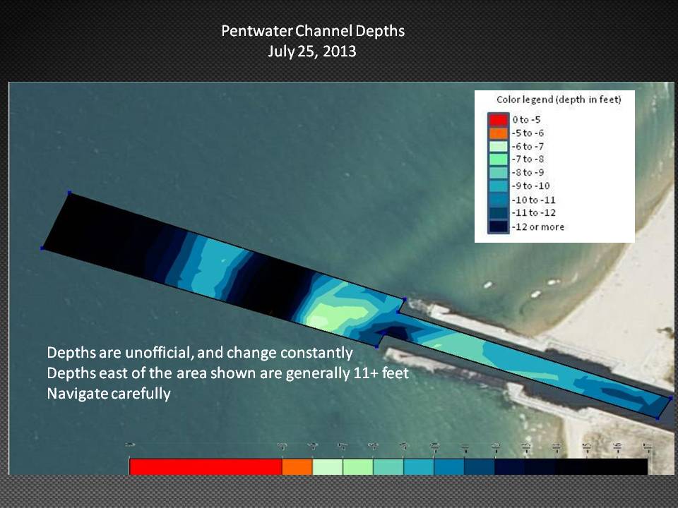
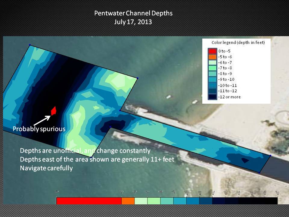
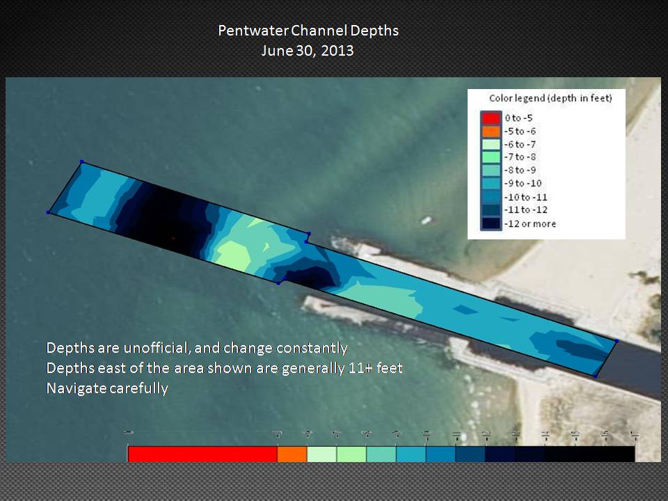
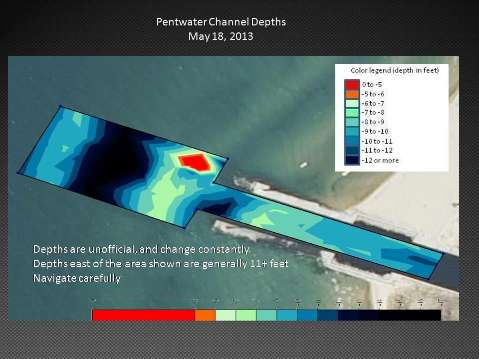
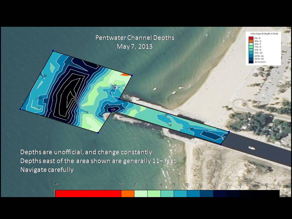
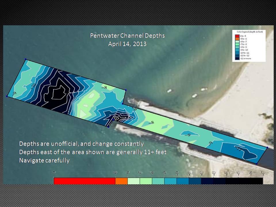
When it became apparent that the government was unlikely to fund the dredging, at least for this year, it was decided to sound the channel to understand the magnitude of the problem. A web search found a very nice program named Undersee Explorer. This program takes the input of a fishfinder, and produces a detailed contour map of the bottom of any body of water. A Garmin 441s fishfinder, which combines GPS and sonar, was purchased. Jack Witt of Snug Harbor Marina provided a boat, and Milt Pugsley, Jack Patterson, Andrew Witt and I gathered the data. A grid pattern was driven, and the data read into the USB port of a laptop computer. Details of the methods used are here.
As originally written, UnderSee Explorer did not calculate volumes of the material to be dredged to achieve various depths. William Burlison kindly added this, and several other features. Our initial calculations showed that approximately 3,000 cubic yards would need to be removed for a depth of 11 feet, and 6000 yards for 12 feet. These volmes are consistent with previous dredgings.
Corps of Engineers, 1938 from Pentwater Historical Society
Click the photo for additional photos
Pentwater Lake is geologically a "Drowned River Mouth Lake." According to Jack Patterson, the original outlet to Lake Michigan was apparently just south of the old Nickerson Inn.
"Lumber baron, Charles Mears, built the channel to Lake Michigan and placed his sawmill on its north bank in 1855. A store and boarding house were built next nearby. Mears called this site Middlesex and included all of the land east to Hancock Street. Middlesex was absorbed into Pentwater when the village was formed in 1867. In 1858 Mears established a ferry service across the channel. He also built a 660 foot long pier out into Lake Michigan from the north bank of the channel so that the largest boats on the lake could haul lumber to his yards in Chicago and drop off cargo for the village. In 1920, Mears' daughter, Carrie, deeded 600 feet of beach north of the channel to the state of Michigan as the beginning of the present Charles Mears State Park." [From Small Town Gems]
The status of the channel in 1867 is detailed in Executive Documents printed by order of The House of Representatives during the Second Session of the Thirty-Ninth Congress, 1866-1867, p 293ff. [1] [OCR version related to Pentwater Harbor]
From that report:
"The present improvements at this harbor were made by private enterprise, and consist of piers made of slabs, with a wharf of piles, 560 feet in length, extending out into the lake on a prolongation with the north pier. These piers are about seventy feet apart at the inner end, and about one hundred and ten feet at the lake end. The depth of water between the piers varies from two to six feet."
"In 1868, the Federal Government began a 20-year project to provide a wider, deeper channel than Charles Mears had been able to achieve since he built his "river" in 1855. A lighthouse was built on the south pier with a catwalk leading to it so that the keeper could tend the oil lamp. A life saving station was built on the north pier in 1887. Visitors could watch the crew's weekly drills. Many rescues are credited to the station. In 1915 the Coast Guard took over. Operations continued at various levels until 1958 when the station site was cleared. Only the flag tower, on which flags and lights warned vessels on the lake of dangerous weather, remains. The historic piers are now public promenades. The station site is a park. The piers are listed in the National Register of Historic Places." [Pentwater Chamber of Commerce]
"Between 1856 and 1858, Charles Mears and his crew excavated a shallow channel that would allow boats to haul lumber from his mill out to Lake Michigan. The steamer DAYLITE became the first large vessel to navigate through the channel into Pentwater Lake. As more mills moved into the area, Mears and Michigan Senators lobbied for harbor improvements, finally receiving the funds in 1867. These improvements included widening and deepening the channel, along with extending the piers. It was determined that a light was now needed to help guide vessels into the channel. A 12-foot timber-framed was built in 1873 on the south pier, and contained a red Sixth-Order Fresnel lens, visible for 8 1/2 miles. Local resident Francis McGuire became the first keeper of the Pentwater Lighthouse, and after four years, his wife Annie took over the job.
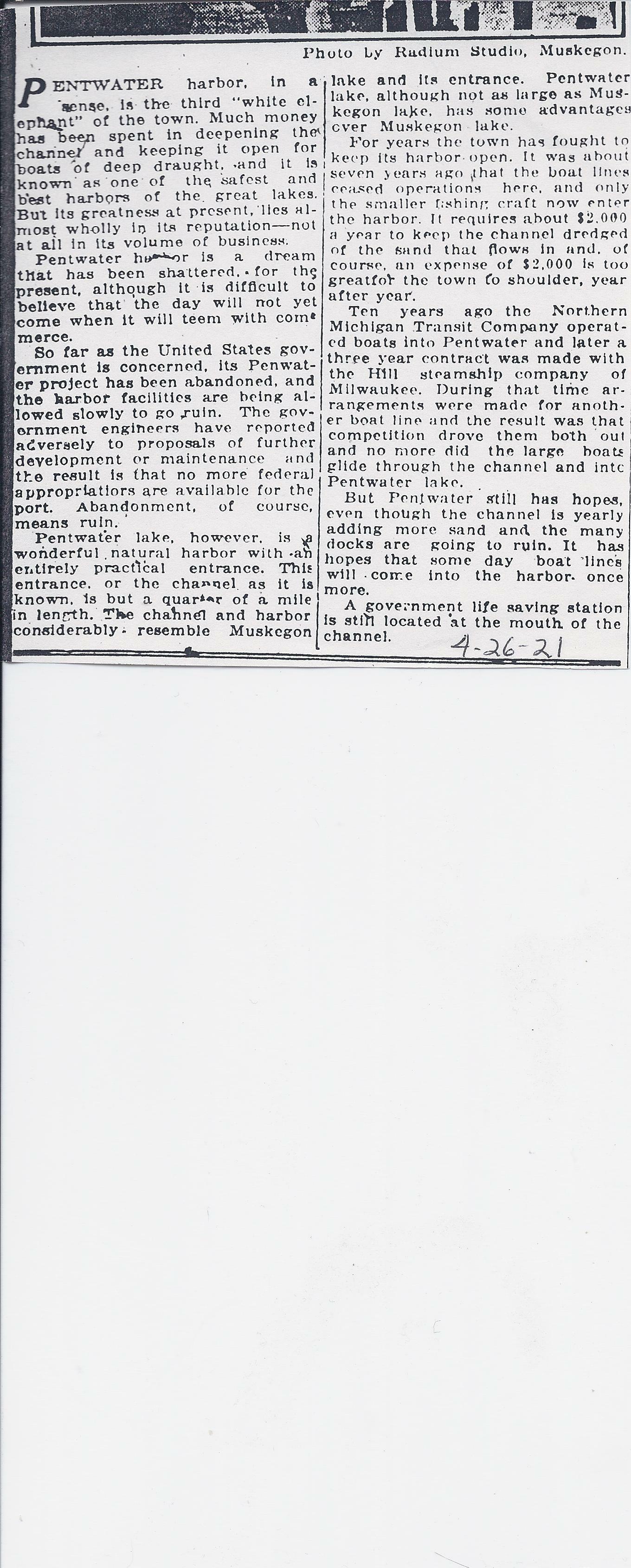
A newspaper article dated 4-26-21 shows that history is at risk for repeating itself:
"For years the town has fought to keep its harbor open. It was about seven years ago that the boat line., ceased operations here, and only the smaller fishing craft now enter the harbor. It requires about S2.000 a year to keep the channel dredged of the sand that flows In and. of course, an expense of $2.000 is too great for the town to shoulder, year after year." [1] [OCR version]
"The Army Corps of Engineers replaced the timber piers with concrete in 1937, and the South Pierhead Lighthouse was replaced by a steel skeleton tower. Sixty years later, in 1997, a tower was erected on the north pier, and outfitted with a 300mm flashing green Tideland Signal optic, and also included a fog signal.
The current South Pierhead Lighthouse stands 25 feet tall, with the North Pierhead Lighthouse at 17 feet tall. Each is considered one of the few remaining pier range light systems located on the Great Lakes." [Visit Pentwater]
|
Unless otherwise noted, text, pictures and html code are by David Roseman. Send corrections or comments to dlr@eolas.com
Participants in the discussions have included Ed Bigelow, William Burlison, John Carlson, Bob Childers, Ted Cuchna, Mike Flynn, Tony Groves, John Grant, Chip Gwillim, Pat Hooyman, Bruce Koornodyc, Ken Lindstrom, Frode Maaseidvaag, Jim Miller, Tom Osborn, Gary Nicholson, Jack Patterson, Juanita Pierman, Milt Pugsley, Al Ringquist, Dave Roseman, Jean Russell, Norm Shotwell, Chuck Smith, Ron Steiner, Tom Sturr, Marilyn Sullivan, and Jack Witt. Thanks to all.